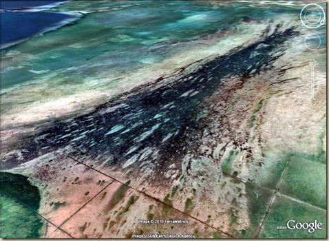
Somewhere in northern Minnesota:
The geologic formation we see in the image below is a little over 13 miles long
Firestone 2007 stated that:
“Hypervelocity oblique impact experiments (P.H.Schultz, unpublished data) indicate that a low-impedance surface layer, such as an ice sheet, can markedly reduce modification of the underlying substrate if the layer is equal to the projectile’s diameter. These results suggest that if multiple 2-km objects struck the 2-km-thick Laurentide Ice Sheet at 30°, they may have left negligible traces after deglaciation. Thus, lasting evidence may have been limited to enigmatic depressions or disturbances in the Canadian Shield (e.g., under the Great Lakes or Hudson Bay), while producing marginal or no shock effects and dispersing fine debris composed of the impactor, ice-sheet detritus, and the underlying crust. “
A couple of those high velocity impact experiments can be seen in the YouTube video below. Please pay particular attention to the experiment about halfway through that simulates an oblique angle high velocity impact into an ice covered surface. That’s the “unpublished data” mentioned in Firestone 2007.
Did you notice the randomized character of the sub-ice target surface in that ice sheet shot? With those ice sheet impact experiments in mind, I’m thinkin’ that folks who’re looking for nice orderly, and round, craters and impact structures in The Great lakes Region, and Canada as the residual planetary scarring, and ‘smoking gun’ of the YD impact event after the ice melted in the Great Lakes region are chasing red herrings. The laurentide Ice Sheet was up to two kilometers thick. So even a direct high velocity impact there as large as the one that produced Barringer Crater in Arizona probably would’ve left no trace in the sub-ice surface. And I’m betting that none of the ice sheet impacts left a recognizable crater. But that’s not to say that there is no residual planetary scarring to be found.
One might note that the flows of “fine grained felsic volcaniclastic”, and “volcanogenic” rock that constitute the so called “Patterned Peat lands of Northern Minnesota”. Those patterns in surface emplacements of igneous rock on the southern edge of the Canadian Shield cannot be accounted for by a volcanic system young enough to account for surface flows of “volcanogenic” rock that have not been modified, damaged, or scraped away after emplacement by the movement of the glacial ice of repeated ice ages. And I’m thinkin’ that the weird patterns of those peat depressions just might be the “enigmatic depressions” we’re looking for.
Thank’s to the generous support of Quantum Future Group I’ll be spending a few weeks of the late summer, and into the fall until the snow flies, on the ground there backpacking, and wandering around the Patterned Peat lands, and that great big black splash of ??? that’s up there and answering the question of just what the heck is that stuff? And where did it come from if not out of the ground?
If you’d rather see more recent, and detailed imagery of the place in Google Maps. just click this Link.
