I’ve been reading a paper, Wagespack and Surovell 2003, as a starting point to see what Surovell’s other papers are about. His paper attempting to shoot down the Younger Dryas Impact hypothesis was pretty bad science; since he was incapable of following test protocols. So when I got a line on some of his other papers, I decided to see what kind of work he normally does.
In this paper I am seeing that he makes an awful lot of assumptions, ones he thinks are reasonable. But his selection of data is dumbfounding. He seems to just make shit up too; such as a table on what the average density of mammals large and small over the whole of the USA. With the vast array of ecosystems slash environments in the USA, it is unfathomable that anyone would make up ONE table and give ONE average density and think it could or would apply to the entire country. One of the oddest things about it is that it includes both Asian elephants and African elephants – but does NOT include mammoths – the subject of his paper.
To cut to the chase, let’s show some maps…
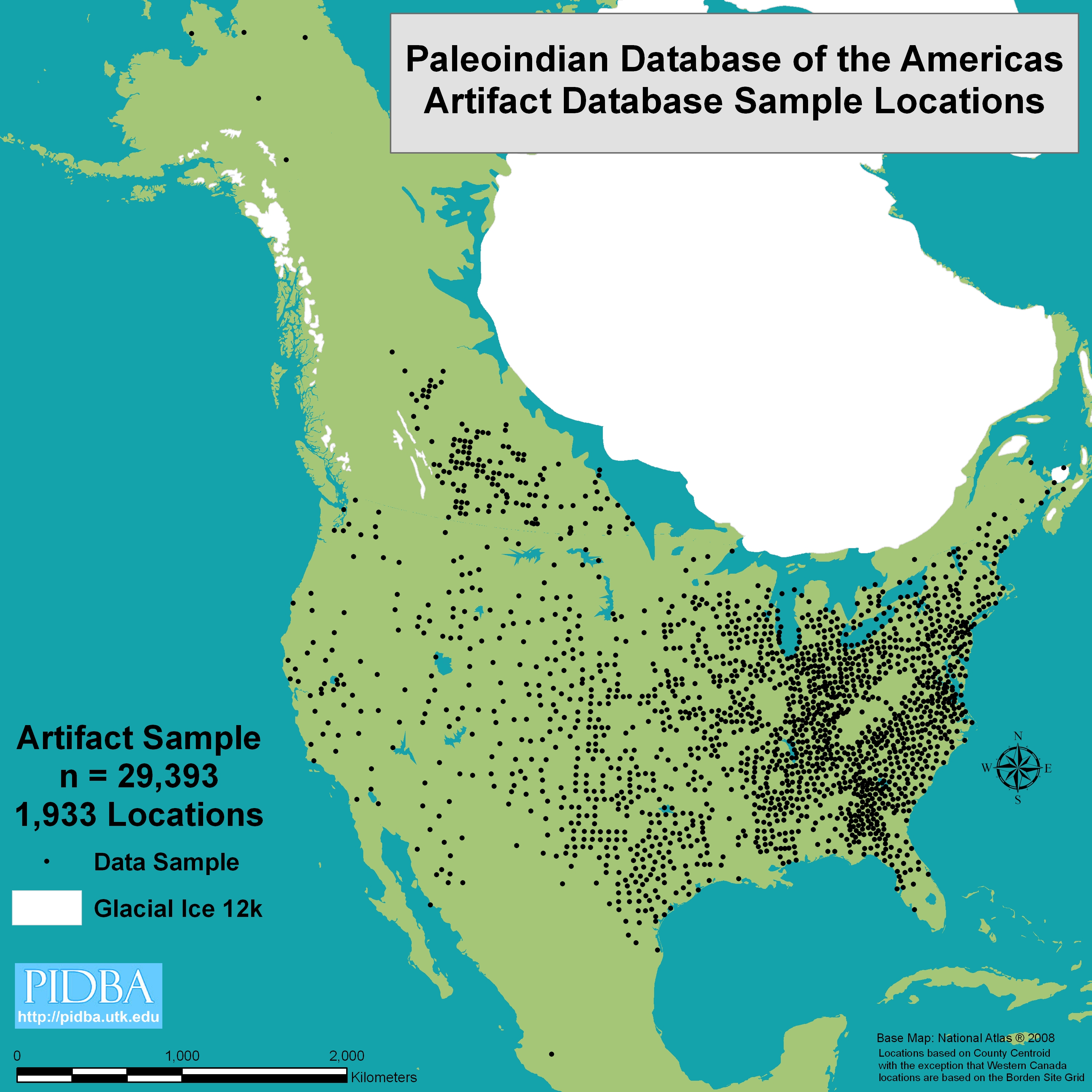
I LOVE this map! Except for a few regions (which may be a long term sampling problem) you might match this up quite well with maps of population density in North America in modern times. Does this mean, I wonder, if Paleo-Indians were as bright as we are in terms of livable land? Also, note the quite dense artifact density in the Southeastern and Appalachian regions. (source: http://pidba.org/content/PIDBA%20Figure%2001.jpg)
And here, Surovell’s/Waguespack’s map, discussing the hunting preferences of Clovis Man, which purportedly is discussing how Clovis Man might have hunted other game than mammoths and mastodons. Note that where the most PEOPLE (artifacts) are found, Surovell and Waguespack don’t show ANY sites studied. They ONLY show them in the regions where mammoth bones and mastodon bones have been found.
Okay, so those captions should give some idea of where I am going. S&W 2003 biases their entire paper by using data ONLY from locations INSIDE the mammoth-mastodon areas. Now if the real purpose of the paper were to offer that Clovis Man actually hunted OTHER than mastodons and mammoths, one would think the authors would pay SPECIAL attention to the areas where it seems mastodons and mammoths simply didn’t go – the areas in which hunters COULD NOT hunt mastodons and mammoths, simply because there WERE NONE.
If Clovis Man was a predominantly or solely mastodon and mammoth hunter, WHY would they locate so much in areas where mastodons and mammoths didn’t exist?
It doesn’t matter WHAT they found in areas where mastodons and mammoths DID exist, if the question is “What else might they have hunted?” The clear answer would SURELY be in the regions lacking mastodons and mammoths.
Is it just me, or does everyone smell cherry picking?
Yet W&S simply IGNORE that region.
They make sure that they ONLY look in mastodon and mammoth regions to find out wheat else Clovis Man was eating. One would think it is only necessary to look at what was in the Tennessee River Valley and the lower Mississippi Valley, and the Great Smokies and Blue Ridge.
My one visit to the Smokies/Blue Ridge area happened to be in August of 1997, when everything of north was all brown and dried up from lack of rain and too much sun. Even lower down, around Charlotte, everything was brown and dried up. Not so, the Blue Ridge. I honestly thought it was the greenest place I’d ever seen. My traveling companion, my boss, told me that it was the original home of the Cherokee Indians. I could see why they would choose it – they weren’t stupid. Neither, I suspect, were the Clovis people who lived there. If heaven has any prettier places, then heaven is worth seeing.
In climate change/global warming articles and most papers, it is humorous how, even when it isn’t appropriate, in the last paragraph or so, there is some bow to the “CO2-is-evil” mantra. Shall we put this cherry picking by W&S down to obsequiousness on their part, a bow to the OTHER mantra? That “Clovis Man-was-Evil”?
* * * *
And now, to add insult to injury. . .
It is WELL KNOWN that all searches for Clovis points in Siberia have turned up nothing. The standard line that Clovis Man was THE first people to come to the Americas – called “Clovis First” – was busted in 1997 with the long overdue acceptance of the Monte Verde site in Chile, which predated by about 1,000 years the opening or the :ice free corridor” in the eastern Canadian Rockies.
A VERY IMPORTANT POINT: The vast majority of mammoths were not in North America. Where WERE they? In Siberia! and where is the evidence IN SIBERIA that humans were killing off the mammoths THERE?
If you answer “none” you win the golden ring.
Look at the maps above and see how FEW flaked points have EVER been found in the NW of North America. String that together with Siberia and we have a VERY long trail of. . . well, pretty much NOTHING. The Hansel and Gretel trail that SHOULD point back to Siberia – DARN! It isn’t there!
So, in Siberia – where the Clovis people were supposed to have come from -there are no Clovis points or anything LIKE them, AND in Siberia there is no evidence of humans wiping out mammoths. No evidence. No evidence. But for close to SEVENTY years, that was what was not only taught and repeated, but defended almost at the point of a gun.
Now, where do we REALLY see Clovis points? (Trust me, people, they do NOT want you noticing this…)
In the FAR CORNERS of North America, that’s where. The farthest regions from the corner where the Asians came from.
One of two things is suggested as most likely here:
1. The men that came from Asia (and the DNA does say that they DID), did NOT bring Clovis points with them. (this would suggest that the Clovis points met up with them in the Eastern USA. In other words, there would be no connection at ALL between the Clovis points and the people as they crossed Beringia.
2. The mammoth hunters came OUT OF THE EAST – evidently AFTER encountering the bifacial fluted points now called Clovis points.
It all remains to be see.
But the “Clovis came over Beringia” idea is based on PREMATURE conclusions, so common in paleontology and archaeology. Out west they had a FEW evidences of Clovis points in widely dispersed locations, and the first ones were found out West, and they had already decided that the first Americans had come over the land bridge, so they simply mooshed the two ideas together, without even ONCE saying that the idea was tentative. So since they found them out west first, of COURSE they came from somewhere out west, right? VOILA! Clovis Man came over the land bridge and started killing mammoths for all they were worth.
It was a simple random – and VERY misleading – chance occurrence that that first Clovis point was found near Clovis, NM, instead of in, say, Kentucky. If that point had been found in the East somewhere, the bulk of the 20th century would not have been wasted on that stupid, STUPID premature conclusion.
Published in: Uncategorized
on May 10, 2014 at 9:33 pm
Comments (8)
“Toon et al. suggest that an impact capable of continent-wide damage requires energy of 10^7 megatons, equivalent to an impact by a 4-km-wide comet . Although an impactor that size typically leaves an obvious large crater, no such late Pleistocene crater has been identified. The lack of a crater may be due to prior fragmentation of a large impactor, thereby producing multiple airbursts or craters. Hypervelocity oblique impact experiments (Peter. H. Shultz , unpublished data) indicate that a low-impedance surface layer, such as an ice sheet, can markedly reduce modification of the underlying substrate if the layer is equal to the projectile’s diameter. These results suggest that if multiple 2-km objects struck the 2-km-thick Laurentide Ice Sheet at 30°, they may have left negligible traces after deglaciation. Thus, lasting evidence may have been limited to enigmatic depressions or disturbances in the Canadian Shield (e.g., under the Great Lakes or Hudson Bay), while producing marginal or no shock effects and dispersing fine debris composed of the impactor, ice-sheet detritus, and the underlying crust.”
A couple of those high velocity impact experiments can be seen in the YouTube video below. Please pay particular attention to the experiment about halfway through that simulates an oblique angle high velocity impact into an ice covered surface. That’s the “unpublished data” mentioned in Firestone 2007.
Did you notice the randomized character of the sub-ice target surface in that ice sheet shot? With those ice sheet impact experiments in mind, I’m thinkin’ that folks who’re looking for nice orderly, and round, craters and impact structures in The Great lakes Region, and Canada as the residual planetary scarring, and ‘smoking gun’ of the YD impact event after the ice melted in the Great Lakes region are chasing red herrings. The laurentide Ice Sheet was up to two kilometers thick. So even a direct high velocity impact there as large as the one that produced Barringer Crater in Arizona probably would’ve left no trace in the sub-ice surface. And I’m betting that none of the ice sheet impacts left a recognizable crater. But that’s not to say that there is no residual planetary scarring to be found.
I’ve watched every available YouTube video of the ice sheet impact experiments Dr Schultz conducted at the HVGR, and there is a place in the great lakes region that seems to fit the description given above, and the post impact target surfaces of those experiments, to perfection. And the number, and scale of those features is also consistent with multiple 2-km+ objects
It’s called “The Patterned Peatlands of Minnesota” There’s a very good book with that title by H. E. Wright et. al. And I’ve been interested in the place since the first time I saw it in a satellite image in 2008. I realize that intuition, or a gut feelings have a tenuous place at best in science. But there was just something about the shape and directionality of those patterns that does not jibe at all with the idea that they were created by the normal linear passage of glacial ice during the last ice age, or by normal riparian processes during the past 13,000 years or so since. In order for them to have formed as a result of erosion you need moving, flowing water. And the water in the Patterned Peat Lands is some of the most stagnant wetlands on Earth.
If you read the book above you’ll see that the hydrology, and biota of the area has been very thoroughly studied. And many cores have been taken of the deposits of peat. So the formative ecological processes that created the bogs, and how old the peat deposits are, is very well understood indeed. Unfortunately, the same cannot be said for the late Pleistocene, early Holocene geomorphology that created the strangely shaped depressions that have no inflow or outflow channels, and that the PPL are setting in to begin with. Writing about the environment aspects of the place only describes it in an ecological framework. And the simple fact is that the formation of peat since the LIS retreated only filled the depressions with stagnant, anoxic, water and ancient dead vegetable matter that isn’t able to decay. It couldn’t have formed them. Something else had to have done that.
Early on a friend of mine in the Air Force reserve was able to log a LIDAR flight over the area as a training mission. But in the long run his contribution was more of a confusing hindrance than help. Because unfortunately, while his skills as a pilot operating a LIDAR equipped aircraft may be unmatched, he wasn’t so sharp at interpreting the data that equipment was collecting. According to him the image he’d provided was a false color image depicting altitude that graded from darker = lower, to lighter = higher. But what my pilot friend wasn’t clear about was the reflective effect that the water in a wetland environment would have on the LIDAR data.
It was almost impossible to conceive of any normal geologic process that could leave such strangely shaped raised terrain features after an ice age. But it was also impossible to imagine, and think trough, a plausible way for them to be deposited as raised features left on the sub-ice surface by an ice sheet impact event. I didn’t believe for a minute that glaciers could do such a thing. After all, they haven’t done so anywhere else on Earth. But no amount of grappling with it could come up with a way I was completely comfortable with for an impact event to do it either.
The enigma was too much, my overwhelming curiosity got the best of me, and I just had to go there personally and see the place for myself.
Thanks to the generous support of Quantum Future Group I was able to take off on a road trip to go and spend a few weeks on the ground there. I was able to figure out that in this case his explanation was ass backwards, and that in fact in his image Lighter = deeper, and wetter; Darker = higher, and dryer. So what I had at first perceived as something that had been somehow deposited on top of the sub-ice surface was in fact where something had gouged into that surface. A few weeks on the ground there also convinced me more than ever before that the place is indeed the remaining scars of a major impact event into the ice of the LIS. But the mechanism of the event must have been vastly different, and probably more violent, anything I was imagining before going there.
I still couldn’t imagine a way for the linear movement of an ice sheet to gouge randomly flowing depressions, and patterns into the hard and archaic igneous bedrock of the Canadian Shield; much less a linear gouge that’s perfectly perpendicular to that flow of ice. But when considering them as locations where some of the energy of a very large multi fragment impact event that was violent enough to do continent-wide damage penetrated the ice and gouged into the sub-ice surface, it’s not hard to work out a plausible way to get those randomized patterns at all.
A few multi-gigaton, low angle, impact induced, hydrothermal explosions blowing the Laurentide Ice Sheet to smithereens can explain most of the randomized and flowing patterns. And for the most dramatic depression of them all, namely the arrowhead shaped gouge just west of the patterns, and north of the Red Lake Indian Reservation, all we need is for some of the kinetic energy of one of the larger fragments to have penetrated all the way through the 2-km+ ice of the LIS.
The rock composition of the bedrock for the general area of the black arrowhead shaped bog depression is labeled on the USGS’s geologic maps as: "Para gneiss and schist-rich migmatite -grades into undivided meta sedimentary rocks." And the meta sedimentary rocks are further described as: ‘Meta sedimentary rocks-undivided-greywacke, slate, local units of conglomerate, arentite, graphic slate, fine-grained felsic volcanogenic, and volcaniclastic rocks, lean oxide iron-formation and its metamorphic equivalent. Includes the Knife Lake Group and the Lake Vermilion Formation in northeastern Minnesota.’
Migmatite is a rock of both metamorphic, and igneous origin that exhibits characteristics of both rock types. It forms under extreme temperature conditions during metamorphism through the heating (but not quite melting) of rocks in the presence of a lot of water, and where partial melting occurs in pre-existing rocks. Migmatites aren’t crystalized from a totally molten material, and are not generally the result of solid state reactions. But are composed of a new material crystalized from incipient melting, and an old material that resisted melting. I’m wondering if that might be exactly the kind of rock we should expect to see in the burn scars of impact induced hydrothermal explosions in the Laurentide Ice Sheet. And I’m especially suspicious of the words “Volcanogenic”, or “Volcaniclastic” anywhere in the Canadian Shield because except for some dyke activity that dates to about a million years or so, the Canadian Shield isn’t supposed to have seen any volcanic activity in more than 2.5 billion years.
So I can’t help but wonder how long it’s been since that stuff was in a molten state. But if the area is in fact a location where some of the kinetic energy made it all the way through the ice sheet without being converted to heat, there should be some shock metamorphism to be detected in some of the quartz grains.
One of the things that going there personally and exploring the place for myself has taught me is that if you want to get a good handle on interpreting the true color images from Google Earth it helps to pay attention to the time of year in the image date at the bottom of the page as it will have a huge bearing on what kind of terrain and flora is indicated by any given color.
For example, the GE image above showing a close up of the distal, or western end of the arrowhead shaped depression of the Big Red Lake Bog is actually from two different dates, and seasons, a couple of years apart, and stitched together by GE into an almost cloudless image. The left half is from May 8, 2013. And the right half is from Sep 9, 2011. So on the left we see the flora of very early spring. The last frost is behind them. But it’s still too early in the season for the deciduous trees to be showing any leaves yet. The native grasses haven’t awakened yet either. So for the most part the only green in the left half of the image is that of lowland evergreen forests. On the right we see the flora of late summer. So everything on that side is green and verdant. And from high up it’s difficult to tell the difference between one shade or the other. But the real clue is in the huge dead zone visible on both sides of that image, where little to nothing can grow or live at all, no matter what time of the year it is.
In both halves of the image the areas that grade from a dark tan to light brownish grey in the patterns are floating bog conditions that would make anything described in a J.R.R.Tolkien novel pale in comparison. The inner areas of that big Arrowhead shaped bog are almost completely inaccessible except by some sort of specialized, floating track vehicle. But the old timers will tell you that the bog surface in anywhere but the arrowhead shape you see above consists of a mat of anywhere from 18” to 36” of vegetable matter that moves like a giant water bed. Below that you’ll find anywhere from 3 to 15 feet of almost completely anoxic water the color of bad black coffee. And finally a deep layer of peat before coming to the early Holocene sediments, and finally the hard igneous rock of the basement bottom. It’s all a dead zone. And the reason that even grasses have difficulty there is the lack of oxygen in the water. There aren’t even any game trails across it. And the pilot I met while there, and who flew me over the area, said jokingly as we flew over it that there probably weren’t even any mosquitoes living down there because there wasn’t any blood for them to feast on.
The large arrowhead shape you see in the images becomes more pronounced, and visible in wetter years. And the black color is more of that dark stagnant water. But that bog is the deepest depression of them all with the exception of upper, and lower Red Lakes. The local folks told me that 2013 was the second of the two driest years in living memory. So when flying over it in late September there was very little of the black, open water showing at all, just a vast, wet, brownish tan dead zone.
The view below was taken from about 2,500 feet up looking east from the west end of the large arrowhead shaped bog
Some of the older locals who’ve lived in the area for a lifetime, and who’ve explored the wildlife management area it sits in, estimate that at it’s deepest point on the east end it could be as much as 60 feet to the basement rock of the bottom. And in an area that’s mostly as flat as a parking lot, a 60 foot deep depression is extremely dramatic relief. You’ll find the material that was excavated from it in an ejecta layer extending out to the sides, and the distal, or west, end that’s thick enough to support the evergreen forests surrounding the bog; and high enough above the extremely shallow water table of the region for them to thrive.
Another set of features you’ll notice in Google Earth is the set of lines incised into the terrain that form a grid of rectangles, each 1 mile wide by 2 miles long. It seems that back around the turn of the century some bright boy in Washington got the bright idea to dig ditches to drain the swamps, and hopefully turn the area into good arable farmland. They gave a lot of farms away on a first come, first serve basis back then. And it could have worked too. Whole new communities were thriving for a while. But never underestimate the power of the mighty phuque ups in Washington to tax a really good idea into oblivion. The ditch tax they levied on those fledgling farmers struggling to start up and run a small family farming business was too much. And when they couldn’t pay their ditch taxes the government took their farms. Then without a tax base, there were no more funds for ditch maintenance. The ditches all became clogged with overgrowth. And the swamps, and mother nature took over again. Uncle Sam finally threw in the towel and the Minnesota Department of natural resources resolved to call it the Red Lake Wildlife Management Area forevermore.
If you get a wild hair to wander up there and have a look at the place like I did the thing to keep in mind is that while they don’t show up on any road maps of the area, every one of those old ditches is paralleled by a perfectly good access rd.
The center of the Big Red Lake Bog is extremely difficult to get to, even in a good year. So even if I had had the kind of equipment required to get a core down to the bedrock of the bottom while I was there, I’d have had to wait and come back in the winter when the trails around it can be reached by snowmobile in order to haul that equipment out there. But I reasoned that since the slightly raised areas with evergreen forests surrounding that bog have all the characteristics of an ejecta curtain around an impact structure then, if it is the work of an early Holocene impact event, a soil specimen from the edge at the west end of that ejecta curtain might be just as informative. And in fact, while I have not had the chance to look at it in detail, it was encouraging to notice that the small rocks, and gravels in the sample I dug up there do not have the rounded, tumbled appearance of normal glacial til. These little rocks are all sharp, and jagged like freshly crushed rock. I can’t wait to get some of this stuff under a good microscope!
So I’ve got some of it. I was also able to get at an exposure in a ditch at a construction site on a farm about 20 miles from there where we can see the transition from the sub-ice clays of the LIS to the sandy lacustrine conditions of the Lake Agassiz sediments exposed, and presented like a prize. And I was thinking that if the area was hit by an impact event at the end of the last ice age, then some of the debris of that event would have been deposited in the transition layer between them. So I took some of that with me too. And one of these days when I’m done with this walkabout I hope to look for more clues in that stuff under a decent microscope. Not to mention getting them into someone’s lab for a more thorough analysis if anything interesting turns up under that microscope.
But that’ll have to wait. Because my next stop will be a couple of weeks at Big Bend Ranch State Park, Texas to look at the burn scars of a completely different kind of catastrophe.
I’ll post a lot on that place before it’s over too. But in the meantime, like an ass into the desert go I forth to do my work.
Here is a list of reputable pro-Younger Dryas publications, as well as a flock of high-end science journals covering both sides of the debate. Clearly Dr. Nicholas Pinter was ill-informed of this vast list of creditable journalistic reference. I would hate to think that he knows of it and simply ignores it on purpose….
At this point folks like Nicholas Pinter are blindly ignoring the facts. He is not the only one, nor is he the highest ranked scientist among that group of YD impact skeptics. Its kind of a shame but speaks volumes about their own predetermined views despite overwhelming evidence in support of some kind of bolide impact event coincident to the onset of the Younger Dryas cooling:
I am a scientist. A rocket scientist actually. I come from an aerospace education and career as a dynamicist in that field working both spacecraft and aircraft. I went that route with a strong background in it before I ever went to college.
Although not a Geologist or a Chemist, I do have a solid technical background in the physical sciences of thermodynamics, heat flow and hypersonic impacts, including their vastly detailed implications to geochemistry, geomorphology, ocean waves and atmospheric waves.
I’ve been studying it for over 25 years now and I can’t put it down. Eye opening.
My guess is that you may have already been bombarded with messages regarding the above link and all of these publications. I offer this to you only on the rare chance that no one else has already done so. I realize that many of the pro Younger Dryas impact hypothesis folks are so passionate as to be quite overbearing. That is not my desire. Longwinded, yes. Overbearing, no.
CONSENSUS
In science as in life, it is always important to question consensus. Catastrophists have a saying about consensus and define it as the following:
"Consensus" is often used as a marker to identify complacency among a group of specialist scientists where a lack of hard evidence exists.
Nature frequently surprises us with more beautiful truth than our limited imaginations can preconceive. When this is the case, humans typically fill in the difference with consensus, using a crow bar to pry into place what our limited minds would like to be the case. This is a natural process of the human effort to understand our environment, either micro or macro. It is most commonly observed within groups of specialists who are most diligent in their effort to explain limited observations or measurements. They form a consensus. Too often the consensus is actually a crutch or a crowbar….
HARD EVIDENCE vs. COINCIDENCE
There is no hard evidence that an extraterrestrial impact directly or indirectly caused 1400+ years of cold climate in the Northern hemisphere. There is, however, rather precise evidence that a cosmic impact event occurred, and of the exactly coincident timing between that impact event and the onset of the historically significant Younger Dryas cold period, (complete with its hemispheric burnings and continental species extinctions, etc….)
Coincidences of this precise nature must always be further investigated with an open mind. This is especially true with important topics such as historically recent climate collapse, mass extinctions, and hemispheric combustion catastrophe!
SPECIALTY vs. CROSS-DICIPLINARY, & THE EGO
Specialists of every scientific field want to explain the perplexing, startling and rather frightening recent climate fluctuation of the Younger Dryas with their own science, to the point of obsession. They want to claim ownership of the answer. This is a natural defense of the ego, to justify the intense personal effort put forth by such creative, technically minded individuals. Entire careers are often perceived to be at stake in such a major controversy as the Younger Dryas and its causal mechanism.
Ironically it is often the generalist scientist who comes to the limited data of some scientific specialty with no vesting in the specialty consensus of that camp, to figure out a bigger, interdisciplinary framework of possibilities. History has many examples of outsiders providing the answer, which may explain the insecurity of such specialists as Nicholas Pinter when addressing possibilities of Younger Dryas causal mechanisms, or even so much as admitting the evidence for an impact at that epoch exists at all.
It could easily be a case of "blinding by consensus."
THE FREQUENCY OF CHANGE
It is interesting to note that dynamical processes in nature take place over a huge range of time scales. Many types of unstable subatomic particles decay over a time scale of billionths of a second. Many geologic processes take billions of years. Physical science is full of examples of processes that play out over every different time scale in between these extreme ends of the frequency spectrum.
Geologic science has its roots in a history of thinking where all geologic process is extremely slow, or low frequency. It has only been since the dawn of the space age that impact geology has become a science all its own, describing the physical process of hypersonic impact of large bodies, sometimes planetary in scale. Blindingly fast, these events are Geologically formative throughout our solar system, yet occur over frequencies that are too fast for many to conceive. Quite quick and quite catastrophic….
Although cosmic impacts are now accepted as a geologic process, many geologists still can not accept events which take place over too short a period. The frequency of these impact events as an example, are simply too high mechanically for many Gradualists Geologists to accept. When this is suspected of any given geoscientist, it is often informative to ask them what threshold frequency they consider to be too high for any geologic process. They typically can’t relate to millisecond, microsecond or even full second time scales which are common to any hypersonic impact scenario. They live in a conceptual world where things change over time scales of years, thousands of years, millions of years or even billions of years.
GRADUALISM and THE COMFORT ZONE
Contemplating and accepting hypersonic impacts as a Geologic process requires such cross-disciplinary conceptualization that it often forces the Gradualist Geologist out of their comfort zone. It threatens their confidence by direct challenge to the ego. Believe me, if you ever study geochemistry, you need an extremely healthy and well functioning ego to make progress against that nearly impossible challenge. You have to be good to get anywhere in the study of Geochemistry. So good, in fact, that tolerance of cross-disciplinary solutions may suffer severely as a result.
This is often where we may observe the case of "blinding by consensus". I don’t know Dr. Pinter and I mean no disrespect to him. I hope to meet him some day and perhaps interview him for a production on Modern Science and Catastrophism, if he will talk to me about it. Could be a fascinating conversation….
Thanks for your time –
TimH
Thomas "Tim" Harris 718 344 6016 Brownstone Beam Hand Held Camera Positioner 223 Union St. #1 Brooklyn NY 11231 USA
Published in: Uncategorized
on September 23, 2013 at 8:27 am
Leave a Comment
“Hypervelocity oblique impact experiments (P.H.Schultz, unpublished data) indicate that a low-impedance surface layer, such as an ice sheet, can markedly reduce modification of the underlying substrate if the layer is equal to the projectile’s diameter. These results suggest that if multiple 2-km objects struck the 2-km-thick Laurentide Ice Sheet at 30°, they may have left negligible traces after deglaciation. Thus, lasting evidence may have been limited to enigmatic depressions or disturbances in the Canadian Shield (e.g., under the Great Lakes or Hudson Bay), while producing marginal or no shock effects and dispersing fine debris composed of the impactor, ice-sheet detritus, and the underlying crust. “
A couple of those high velocity impact experiments can be seen in the YouTube video below. Please pay particular attention to the experiment about halfway through that simulates an oblique angle high velocity impact into an ice covered surface. That’s the “unpublished data” mentioned in Firestone 2007.
Did you notice the randomized character of the sub-ice target surface in that ice sheet shot? With those ice sheet impact experiments in mind, I’m thinkin’ that folks who’re looking for nice orderly, and round, craters and impact structures in The Great lakes Region, and Canada as the residual planetary scarring, and ‘smoking gun’ of the YD impact event after the ice melted in the Great Lakes region are chasing red herrings. The laurentide Ice Sheet was up to two kilometers thick. So even a direct high velocity impact there as large as the one that produced Barringer Crater in Arizona probably would’ve left no trace in the sub-ice surface. And I’m betting that none of the ice sheet impacts left a recognizable crater. But that’s not to say that there is no residual planetary scarring to be found.
One might note that the flows of “fine grained felsic volcaniclastic”, and “volcanogenic” rock that constitute the so called “Patterned Peat lands of Northern Minnesota”. Those patterns in surface emplacements of igneous rock on the southern edge of the Canadian Shield cannot be accounted for by a volcanic system young enough to account for surface flows of “volcanogenic” rock that have not been modified, damaged, or scraped away after emplacement by the movement of the glacial ice of repeated ice ages. And I’m thinkin’ that the weird patterns of those peat depressions just might be the “enigmatic depressions” we’re looking for.
Thank’s to the generous support of Quantum Future Group I’ll be spending a few weeks of the late summer, and into the fall until the snow flies, on the ground there backpacking, and wandering around the Patterned Peat lands, and that great big black splash of ??? that’s up there and answering the question of just what the heck is that stuff? And where did it come from if not out of the ground?
If you’d rather see more recent, and detailed imagery of the place in Google Maps. just click this Link.
Published in: Uncategorized
on August 3, 2013 at 12:13 pm
Leave a Comment
On March 6, 2012 when Isabel Israde-Alcántara et al. reported Evidence from central Mexico supporting the Younger Dryas extraterrestrial impact hypothesis their new paper in PNAS immediately superseded Firestone et al. (2007) as the flagship paper for the Younger Dryas impact hypothesis. They reported a 10 cm thick impact layer in Lake Cuitzeo that’s similar to the Cretaceous/Tertiary boundary which marks the impact event that’s blamed for the extinction of the dinosaurs 65 million years ago.
And in central California some of the foothills of the western slope of the Sierra Nevada mountains are blanketed with pristine burnt facies that can’t be attributed to terrestrial volcanism.
We have a bit of a mystery here in California concerning what kind of catastrophe happened at the beginning of the Younger Dryas Cooling. There is compelling evidence that it is related to a large cluster airburst event that hit the western half of the continent 12,900 YA. And there is currently a core drilling project underway in northern California that has the potential shed a great deal of light on things.
University of California, Berkeley, scientists are drilling into ancient sediments at the bottom of Northern California’s Clear Lake for clues that could help them better predict how today’s plants and animals will adapt to climate change and increasing population.
UC Berkeley professor Cindy Looy and graduate student Liam Reidy explain how drilling into Clear Lake can reveal the consequences of past climate change, and help us predict the future consequences of global warming. (Video produced by Roxanne Makasdjian)
The lake sediments are among the world’s oldest, containing records of biological change stretching back as far as 500,000 years.
The core drilling is part of a unique, multifaceted effort at UC Berkeley to determine how Earth’s flora and fauna responded to past changes in climate in order to improve models that project how life on Earth will adapt to today’s environmental pressures. What the researchers learn from their look-back in time will be crucial for state or local planners clamoring for better predictive tools to guide policies crucial to saving ecosystems threatened by climate change.
“We are reconstructing the past to better forecast the future, because we need to know what’s coming in order to adequately prepare for it,” said project leader Cindy Looy, UC Berkeley assistant professor of integrative biology.
Looy and 16 other UC Berkeley faculty members – including paleontologists, pollen experts, botanists, ecologists and climate modeling experts – will examine the lake cores for pollen grains, charcoal and fresh-water organisms going back at least 130,000 years, long before humans arrived in the area. Using isotope and chemical analysis as well as carbon dating, the researchers will obtain a long series of detailed snapshots – ideally, every 10 years – of the plant and animal communities in the Clear Lake area and how the communities changed in response to “natural” global warming events. The analysis will also provide a measure of the temperature, oxygen content and nutrient levels of the lake, which reflect rainfall and water level.
One way to check our predictions is to go back in time to a state very similar to today, with the same plants and animals and about the same temperature. The fossilized plant and animal remains from Clear Lake will give us a baseline for what this region of California looked like under similar climatic conditions, and when it was colder or warmer. We use that information to fine-tune predictive models being developed today,” Looy said. “Rates of global warming almost as fast as what we see today last happened during the shift from the last glacial to the current interglacial roughly 12,000 years ago, so that is one time interval we will focus on.”
Clear Lake, which is about 19 miles by 8 miles at its widest, is located about 100 miles north of San Francisco.
Focusing on two glacial-to-interglacial transitions
Looy and her team also will look at an even earlier transition from a glaciated Earth 130,000 years ago to a time 113,000 years ago when it may have been locally warmer than today. Learning what the area looked like during that time will help Northern Californians anticipate how conditions will change as global temperature continues to rise over the coming decades.
“There are indications from ice cores and ocean drilling cores that the beginning of the previous interglacial may have been warmer than it is now, which is where it becomes interesting,” said Looy. “We know what the Earth is like at today’s temperature, but a lot of people are trying to predict what will happen if the earth warms 1 or 2 degrees Celsius (2-4 degrees Fahrenheit), or even more.”
Charcoal in the lake sediments will also tell the researchers how Native Americans altered the environment through deliberate fires designed, for example, to increase acorn production by oaks.
One member of the team, Anthony Barnosky, UC Berkeley professor of integrative biology, will correlate this information with mammalian fossils collected from cave deposits in the area and that have been stored for decades in the Museum of Paleontology.
“You can view the core as a time machine by which we can define a continuous record of change, both climatic and vegetational, though the past 130,000 years, and then we have all these floating snapshots of the ecosystem – the mammal communities – from cave deposits around here,” Barnosky said. “We can put names on these fossils and radiocarbon-date them and begin to build a 3-D picture of change through time from the late Pleistocene, some 130,000 years ago, through the last glacial/interglacial transition 13,000 to 11,000 years ago, all the way up to the present.”
The study will help to evaluate and refine current models that predict how plants and animals will adapt to a changing world by testing predictions of the models against what actually happened during past times of climate change. Such models are important for state and local planning agencies that must deal with future consequences of climate change, including sea level rise, water shortages and increasing fire incidence that can threaten ecosystems.
“Based on this type of research at UC Berkeley, we want to make the case that adaptation to a changing climate is an issue we have to take more seriously, we have to bring it more into the mainstream of Bay Area planning,” said Bruce Riordan, director of the Bay Area Joint Policy Committee, which coordinates regional planning agencies in responding to climate adaptation. “By starting planning now and understanding the problems, the strategies we need to implement and the costs involved, we may find less costly solutions today rather than later. The research can really help inform about both the problems and about the solutions.”
Half million years of sediment
Clear Lake is unusual in having survived the advance and retreat of glaciers that scoured and obliterated most lakes outside the tropics, including the large lakes in California’s Sierra Nevada. Previous coring in Clear Lake by the U.S. Geological Survey (USGS) in 1973 and 1980 revealed lake sediments half a million years old, with only three breaks in continuity. At the site where UC Berkeley plans to obtain cores, in the upper arm of the lake about 1-3 miles west southwest of the town of Lucerne, the USGS obtained a continuous core in 1973 going back 130,000 years.
Looy and her team hired Utah-based DOSECC (Drilling, Observation and Sampling of the Earths Continental Crust), a non-profit scientific drilling company, to obtain two 120 meter-long (400-foot) cores, each about 8 centimeters (3 inches) in diameter. The cores are obtained in 3-meter (10-foot) chunks that are capped and labeled at the site and will be shipped to a cold-storage facility in Minnesota operated by LacCore (National Lacustrine Core Facility), a non-profit organization funded by the National Science Foundation and the University of Minnesota. In the facility’s cold lab, the team will split each chunk longitudinally, photograph the halves, and then bring one half of each chunk back to UC Berkeley for analysis.
While the USGS sampled its cores once every meter, Looy and her team will sample parts of their cores every centimeter, the equivalent of about 10 years of sediment.
“We will get 100 times better time resolution, and can follow what happens when you rapidly warm the Earth up,” Looy said.
“The detail we can get from Clear Lake is really impressive,” she added. “The material is well preserved, and the USGS did a great job in describing the whole time interval so that now we know what the interesting areas are to focus on. We know this is not a shot in the dark.”
The Clear Lake drilling project is one of seven research projects involving global change forecasting funded by a $2.5 million grant from the Gordon and Betty Moore Foundation to UC Berkeley’s Berkeley Initiative in Global Change Biology, or BiGCB. Each project focuses on a particular California environment and leverages UC Berkeley’s unique museum collections of vertebrates, insects, plants and fossils to provide details about past changes in plant and animal populations.
Since I’ve been talking about Cluster Airburst events since I started this little amateur blog back in 2009, and in light of recent developments in the Younger Dryas Impact Hypothesis, I think it’s time for this humble amateur take this opportunity to write an update.
Last year when I wrote A Different Kind of Climate catastrophe I pointed out that one of the major flaws in the YD impact hypothesis as written in the original 2007 paper was that Firestone et al weren’t working from a valid astronomical model. In fact, they were all over the place with their speculation as to just what the nature of the catastrophe 12,900 years ago may have been, or what had hit us. That’s what got them into trouble and gave opponents to the hypothesis the rallying cry of “Where’s the crater?” But to be fair, they were citing the work of Toon et al in their estimate that it would take a four mile wide bolide to account for a continent wide debris layer. And at the time, Toon et al’s work on impact scaling was respected as the state of the science in the impact research community.
The physicist who came out as the chief skeptic of the hypothesis, Mark Boslough, and who correctly pointed out that it is physically impossible for a four mile wide bolide to have enough time in the atmosphere to break up completely and scatter fragments, and debris, over a continent sized area without making a good sized crater somewhere just happens to be the same scientist who first considered that very large airburst phenomena might be capable of significant melting, and efficient ablation the surface of the Earth without making a crater.
All of the arguments of the skeptics to date have been addressed in this new version. But more importantly for my own work here is that everything I have been saying about the potential for cluster airburst events, airburst phenomena and the fact that the hypothesis should be updated to be in line with Clube & Napier’s work on the Taurid complex is supported in this new paper.
As of this date though, I think I remain the only researcher who contends that very large airbursts have produced significant ablative geomorphology in the geologically recent past. And that the YD event did indeed produce significant planetary scarring. It just wasn’t anything that anyone has ever imagined as possible in an impact event.
I immediately seized upon the work of W.M. Napier in 2010 when I cited his paper titled Paleolithic extinctions and the Taurid Complex here in this article in my own amateur expression of the hypothesis, and my description of what I interpret as some of the planetary scarring of the event. And now it’s official: The Taurid Complex is the stated astronomical model for the event.
Based upon astrophysical observations and modeling, Napier proposed that YDB impact markers were produced when Earth encountered a dense trail of material from a large already fragmented comet. His model predicts cluster airbursts and/or small cratering impacts that could account for the wide distribution of YD impact debris across more than 10% of the planet, including Cuitzeo. Most comets eventually break up as they transit the inner solar system, and previously unknown fragmented comets are discovered by space-borne telescopes, such as the Solar and Heliospheric Observatory, on average every 4 y. As evidence, Earth is bombarded at an average rate of once every 5 d by one of 72 meteor streams or “showers,” massive clouds of debris from fragmented comets. These well-known meteor showers, e.g., Perseids, Geminids, Taurids, etc., are highly dispersed, but in the recent geologic past, each stream was far more condensed, containing many large, potentially destructive fragments. Currently, the Taurid Complex contains 19 large near-earth Apollo asteroids, with diameters ranging from approximately 1.5 km to approximately 5 km. None of these currently threatens Earth but may do so in the future
Impact research is an infant science. And thanks to poor funding for Near Earth Object research, and for impact science in general, we don’t have a very good handle yet on the variety or quantity, of objects out there that might threaten our world, much less a comfortable understanding of the different kinds of devastation that might be released in a catastrophic impact besides what we see in a generic, single, solid-bolide, crater forming, kinetic impact event. But in light of the new data published in this new paper I think it’s time to realize that craters are not the only kind of planetary scarring we can expect in an impact event. And this new work clearly recognizes that single lone bolides, are not the only kind of catastrophic impact event we can expect in the future.
The radical part that the impact community is having a hard time considering is the idea that thousands of small impacts can happen in a single cluster impact event.
And since it has been assumed without question for more than 150 years that the only possible source of enough heat, and pressure to melt the surface of the Earth is terrestrial volcanism, the very idea that a very large aerial burst might be capable of efficient melting, and ablation, of surface rock without making a crater is especially difficult for planetary scientists to accept because it implies that there may be significant planetary scarring from ablative airburst events in the past that has been misdefined as volcanogenic.
Also, the consensus view held by NASA, and most mainstream planetary scientists is that impacts happen at a slow, and predictable rate, one at a time. And that you can therefore estimate the age of a planetary surface by counting the number of craters in any given surface. But the simple unassailable fact is that as W. M. Napier pointed out in his 2010 paper titled Palaeolithic extinctions and the Taurid Complex large clusters of small cometary fragments do indeed exist in short period Earth-crossing orbits that also cross the orbits of all the planets of the inner solar system. In fact they’re fairly common; as these images of comets Linear, and SW-3 can attest.
The problem for mainstream planetary scientists is that if they acknowledge that such large clusters of small fragments really do hit the planets of the inner solar system from time to time. Then decades of work estimating the age of surfaces on the Moon, Mars, and every other rocky body in the inner solar system by counting the number of craters goes right out the window.
In Many of my previous posts I’ve focused a lot of attention on some of the “enigmatic depressions” in New Mexico. And there seems to be a strong resistance to the idea that they could actually be impact structures. The most common assumption I hear is that since there are so many of them, they must be all sinkholes.
But as I pointed out in the post titled Sinkholes n Craters, since all material movement in the formation of a karst sinkhole is downwards, there is nothing at all in that process that could account for raised rims between two overlapping sinkholes. And we can clearly see raised rims between craters in the image below.
Another common argument I’ve heard is that they don’t look anything like the morphology of a crater; citing the lack of obvious ejecta. I don’t know how long those folks would expect any ejecta from an impact event to survive undisturbed under the influence of the wind, and rain. But let’s look at some certifiable impact structures on mars.
Below is a hi resolution image of a fairly small location inside Gusev crater on Mars. The landing site of the Spirit rover is circled in the bottom left of the image. And if you click on the image for an enlarged view, you can make out the three petals of the landing platform the rover drove off of after landing. The largest crater in the image is Bonneville crater. It is 210 meters in diameter, 14 meters deep and its rim rises 6.4 meters above the surrounding terrain.
It does not rain there, but the wind blows. And as you can see, even with the very high resolution, there is also no obvious expression of the ejecta from any of those craters either.
I hope you’ll take your time. And closely compare the images of terrains in New Mexico with this image of the surface of Mars.
The standard assumption has always been that all impact events, great, or small, must be the result of the impact of a single lone bolide. And part and parcel with that assumption is that they rain down on any given surface in the solar system at a slow, and steady, rate.
So the consensus among planetary scientists is that one can therefore estimate the age of a planetary surface by counting the number of craters. The fewer the craters in any given surface, the younger that surface is thought to be.
But while there is nothing in the images of Mars, or the Moon, that might bring the assumption of a steady impact rate into question, from a forensic perspective those in new Mexico describe a different kind of catastrophic impact event. They all appear in surfaces that can be dated to the Late Pleistocene or Early Holocene. And they describe the almost simultaneous impact of a large cluster of small fragments sometime around the end of the last ice age. Or right about the time something caused the mass extinction of most of the megafauna in North America. And triggered a return to Ice age conditions that lasted something like 1,300 years.
Astronomer W.M. Napier proposed just such an event in his 2010 paper titled Palaeolithic extinctions and the Taurid Complex. In that paper Professor Napier points out that the breakup of comets is now a well recognized path to their destruction.
And if if you are wondering how hard clusters of fragments like I’ve described are to be found in the celestial zoo, it doesn’t take much time to find them. They’re really fairly common.
As a matter of fact take a look at a Hubble Telescope image of the fragments of Comet Linear.
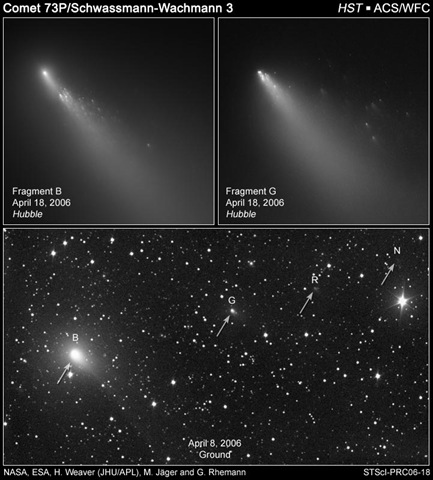
Or the fragments of comet Swchassmann Wachmann 3
The simple fact is that clusters of comet fragments orbiting in the plane of the ecliptic, and in elliptical orbits that cross the orbits of all the inner planets are very common. Therefore cluster impact events must be far more common than has been assumed in the past.
And all it would take is one impact by a cluster of comet fragments like we see above to make NASAs unquestioned assumption that you can estimate the age of a planetary surface by counting the number of craters, and all of the studies based on that assumption meaningless.
Published in: Uncategorized
on February 16, 2012 at 3:09 pm
Comments (7)
One of the major problems with getting a good handle on the impact record of the past is in the naïve assumption that round craters from the direct kinetic impact of a solid object hitting the ground are the only possible planetary scarring we should expect to find.
We are only now beginning to realize that very large airbursts might be capable of significant geologic change. And that the planetary scarring of such an event will have no resemblance whatsoever to an impact crater.
Wilshire et al didn’t have access to high resolution satellite imagery. If they had, they might have noticed that it is a close match for some structures just across the border in North Central Mexico, and that are in almost perfectly pristine condition.
Folks might note that the patterns of motion in the emplacement of the blast-effected materials at the Sierra Madera cryptoexplosion structure, and the numerous pristine examples like it across the border that are in even better condition, i.e. radial outwards at the periphery, and inwards and upwards, at the center, are a perfect match for the bottom of an ablative airburst vortex such as the ones depicted in Mark Boslough’s supercomputer simulations.
In 1972 Wilshire et al could never have imagined that an airburst such as the Tunguska event of 1908 could be large enough to produce significant geologic change. And since the only models for an impact structure they could imagine were the craters we see on the moon and Mars, they assumed without question that it was caused by the impact of a solid object. And they explained the lack of a crater rim by proposing that the explosive event happened in the Late Cretaceous or early Tertiary. And that the crater rim has eroded away in the millions of years since.
But using high resolution satellite imagery, a careful study of the radial patterns of flow in the emplacement of the fluidized flows of breccias and clastic materials surrounding the central uplift of it, and others like it across the border in Mexico will reveal that the structure is in almost pristine condition, and that it was never a crater with a rim.
The entire region is imaged to a resolution of better than 1 meter per pixel in Google Earth; good enough to count the number of cattle a rancher has on his place. And good enough to recognize and read the directionality of emplacement in pyroclastic materials on the surface like following spilled paint back to the can. If the structure were as old as Wilshire et al thought, the patterns of fluid motion in the flows of pyroclastic material at Sierra Madera, and places like it across the border would’ve been erased millions of years ago along with any ring structures. Yet those radial flows of breccias, and pyroclastic material surrounding the central uplifts are virtually undisturbed, and on the surface; a fact that argues for a much younger age for the explosive events that put them there.
Wilshire et al didn’t use any radiometric data. And in 1972 they were still working from the assumption that all impact structures are the result of the impact of a solid object. They couldn’t have imagined that an airburst might be capable of significant geologic change. So their estimate of great age is based on the assumption that enough time has passed to erode away a crater rim. There is no mention of isotopic analysis of specimens from there. But it would be interesting to take a piece of rock that was melted in one of those events, check for ET isotopes, and try to get a definitive age since melt from it.
Once you recognize the real nature of the above ground explosive event that formed the Sierra Madera structure, and its sisters across the border, you also come to the realization that the blast-effected materials of the event, i.e. the radial outwards flowing emplacements of fluidized flows of pyroclastic rock, and breccias, surrounding a central uplift of shatter cones, and blast effects pointing inwards, and upwards, are not the result of a sold object hitting the ground. And that fact forces the conclusion that, contrary to the uniformitarian/gradualist assumptive theory for the mechanics if its formation as expressed by Wilson et al, There never was a crater rim to erode away. The ground at Sierra Madera wasn’t heavily eroded over millions of years, it was heavily ablated over a period of just a few seconds in a large, ablative airburst event. The condition of the blast-effected materials of that above-ground explosion are, in fact, almost perfectly pristine, and they remain virtually undisturbed on the surface since the explosion that put them there. Whatever else the Sierra Madera structure is, geologically old it isn’t.
Published in: Uncategorized
on December 10, 2011 at 10:45 am
Comments (3)
I’ve been talking about the danger posed by fragmented comets for a couple of years now. Here’s a scary article that is supportive of that view. From MIT’s Technology Review we read:
A re-analysis of historical observations suggest Earth narrowly avoided an extinction event just over a hundred years ago.
kfc 10/17/2011
The fragments of Comet Scwassmann-Wachmann 3
The fragments of Comet Linear
On 12th and 13th August 1883, an astronomer at a small observatory in Zacatecas in Mexico made an extraordinary observation. José Bonilla counted some 450 objects, each surrounded by a kind of mist, passing across the face of the Sun.
Bonilla published his account of this event in a French journal called L’Astronomie in 1886. Unable to account for the phenomenon, the editor of the journal suggested, rather incredulously, that it must have been caused by birds, insects or dust passing front of the Bonilla’s telescope. (Since then, others have adopted Bonilla’s observations as the first evidence of UFOs.)
Today, Hector Manterola at the National Autonomous University of Mexico in Mexico City, and a couple of pals, give a different interpretation. They think that Bonilla must have been seeing fragments of a comet that had recently broken up. This explains the ‘misty’ appearance of the pieces and why they were so close together.
But there’s much more that Manterola and co have deduced. They point out that nobody else on the planet seems to have seen this comet passing in front of the Sun, even though the nearest observatories in those days were just a few hundred kilometres away.
That can be explained using parallax. If the fragments were close to Earth, parallax would have ensured that they would not have been in line with the Sun even for observers nearby. And since Mexico is at the same latitude as the Sahara, northern India and south-east Asia, it’s not hard to imagine that nobody else was looking.
Manterola and pals have used this to place limits on how close the fragments must have been: between 600 km and 8000 km of Earth. That’s just a hair’s breadth.
What’s more, Manterola and co estimate that these objects must have ranged in size from 50 to 800 metres across and that the parent comet must originally have tipped the scales at a billion tonnes or more, that’s huge, approaching the size of Halley’s comet.
That’s an eye opening re-examination of the data. Astronomers have seen a number of other comets fragment. The image above shows the Schwassmann-Wachmann 3 comet which broke apart as it re-entered the inner Solar System in 2006. There’s no reason why such fragments couldn’t pass close by Earth.
One puzzle is why nobody else saw this comet. It must have been particularly dull to have escaped observation before and after its close approach. However, Manterola and co suggest that it may have been a comet called Pons-Brooks seen that same year by American astronomers.
Manterola and co end their paper by spelling out just how close Earth may have come to catastrophe that day. They point out that Bonilla observed these objects for about three and a half hours over two days. This implies an average of 131 objects per hour and a total of 3275 objects in the time between observations.
Each fragment was at least as big as the one thought to have hit Tunguska. Manterola and co end with this: "So if they had collided with Earth we would have had 3275 Tunguska events in two days, probably an extinction event."
A sobering thought.
Ref: arxiv.org/abs/1110.2798: Interpretation Of The Observations Made In 1883 In Zacatecas (Mexico): A Fragmented Comet That Nearly Hits The Earth
Published in: Uncategorized
on October 18, 2011 at 10:42 am
Comments (3)
I’ve been going on about some enigmatic, circular, depressions in New Mexico for a few months now. The consensus among those who are skeptical of impact events is that they are all related to karst geology. And that they are all just sinkholes. Many of them are probably just that.
I found a new sinkhole at 32.731966, -104.127823 that would seem to be supportive of that view. It’s in an oil field. And a quick check of the location with Google Earth’s historical image feature reveals that it wasn’t there in 2005. It is almost certainly the result of a water injection well gone wrong. So we can say it’s man-made.
It’s a common cliché that the best place to hide a tree is in a forest. Likewise, the best place to hide a field of small craters is in limestone. No self respecting uniformitarian conditioned geologist would look twice at the thousands of circular depressions in New Mexico.
However, this man-made, but certifiable, sinkhole can be used as a standard example of the morphology of a true sinkhole that others in the state can be compared to.
The injection well created a cavern by dissolving a void deep in the limestone below. Once enough limestone was dissolved, and removed, the the rock was no longer strong enough to support the weight above. And the surface collapsed into the resulting cave, forming a classic sinkhole.
The water from the injection well accelerated the rate at which the limestone dissolved. And the resulting cave would have grown at hundreds of times the erosion rate expected by normal ground water flow. But the collapse itself, and resulting sinkhole, were nevertheless a perfectly natural karst collapse. Making it a good standard model of a sinkhole.
And since all material movement was downwards, there is nothing in the process that formed that sinkhole that could account for raised rims, or overlapping craters with raised rims between them. Nor is there anything in the process we see there that could account for materials thrown outside the hole.
Take a close look at the area shown in the image below. Note the raised rims. Especially between some of the ones that overlap. I won’t speak for others. But as for me, I remain convinced that these things are a field of small impact craters.
Published in: Uncategorized
on September 5, 2011 at 4:49 pm
Comments (3)


