There is significant evidence of massive fires, associated with major ecosystem disruption, and extinctions, at the Younger Dryas Boundary layer at locations in California’s North Channel Islands. See Wildfire and abrupt ecosystem disruption on California’s Northern Channel Islands at the Ållerød–Younger Dryas boundary (13.0–12.9 ka) by D.J. Kennet et al. The nano-diamonds, and other evidences, which have been found on the islands off the coast clearly show that the comet fragments were falling as far west as the Pacific Ocean. This implied that there should be accompanying melt formations in California related to some of those impacts. There are, and they are within walking distance of my home.
lat 36.470550 lon –119.16445

Colvin mountain is about 20 miles southeast of my home. Prospectors have been poking, prodding, and core drilling there since the gold rush days. So we can know a lot about its internal structure. The 2010 Geologic map defines the mountain as Paleozoic mixed rocks. Which is true enough to describe the heart of the mountain. But there is no mention of the pristine, geo-ablative melt formations, and welded breccias, of its outer surface. There is also no mention in the literature of the fact that those thermal glazed, flash melted rocks are as magnetic as any meteorite.
This side of the southern Sierra Nevada batholith hasn’t been volcanically active in 200 million years, or so. Or since the early Mesozoic. There has never been a volcanic vent here. Yet the mountain is covered in fusion glazed, and welded, geo-ablative blast melt, as pristine as the day it first cooled. And the patterns of movement, and flow, frozen into them at the time of their emplacement make it perfectly clear that the ripples of melt were being driven up slope by atmospheric forces like ripples of debris laden froth, and foam, on a storm tossed beach.
The Geologists of the past could not see the clear patterns of movement, and flow in the flash melted stone. Or if they did, they couldn’t conceive of such heat, and pressure, coming from the sky. And they simply ignored their pristine condition, and way they moved as a fluid. To be fair, those patterns of movement, and flow, are only evident from aerial imagery that has only become available in the past decade.
To one driving by on the country roads below, those vertical grooves you see running upslope look like the sides of an ancient, eroded, volcanic plug. So that, when viewed from ground level, on the Valley floor it may appear that the grooves are what we see when intrusive magma cools, and crystallizes. But those melted rocks do not consist of lava, or any form of magmatic material.
The ripples of welded blast melt, and breccias, are a proxy map for the direction of the blast wind blowing over the mountain. The melt is only on the outer surface. And the thermal glaze heat signature is more pronounced on the west, and south, faces of any given foothill in the area. The pristine thermal glaze on the outer surface of the rocks is a common feature in the area, no matter the rock type. On the lee side of the local foothills effected this way, you will typically find house sized mega breccias from the other side of the mountain mixed in with the welded melt.
When you stand among those rocks, and you have a piece of it in your hand, you can clearly see that it consists of partially welded alluvium, and blast melt, that formed in layers as the mist of high velocity, aerosol blast melt accumulated, and mixed, with little clumps of partially welded, ordinary dirt. And that splashed, and tumbled, up-slope in the blast wind. Like the frothing, debris laden, foam on a storm tossed beach.
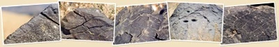
All of the dark exposed rocks you see in these images consist of accumulations of geo-ablative, impact melt. They are as magnetic as any meteorite. And their outer surfaces are covered with 3 mm to 5 mm of black, thermal glaze, that has a remarkable similarity to accumulations of weld spatter, or slag in a foundry. Or the fusion glaze on the outside of a meteorite. And magnetic, thermal glazes of the outer surfaces of those rocks didn’t look any different when it was still fresh, hot, and smoking. Except for some grass growing in the cracks, these flash melted rocks are almost perfectly pristine.
The entire outer surface of this mountain, and much of the west, and south, faces of the local foot hills is so welded that the Friant-Kern canal you see in the image below serves a duel purpose. In addition to carrying water from Friant damn, which holds back lake Millerton, It provides flash flood protection. When it rains here, the water runs off welded slopes like this like water off a roof. So the canal is also a rain gutter.

The Geologists of the past who produced the 1966 California Geology map defined the mountain as Mesozoic. And on the new 2010 map the mountain is defined as Paleozoic mixed rocks. But having hiked among those ripples of pristine blast melted stone, I can tell you that neither map is correct. Because, in fact, those dark ripples of windswept melt consist primarily of recognizable fragments of partially welded alluvium, swept up into the blast wind from the valley floor. The melt is as magnetic as any meteorite. And it’s all finished off with that fusion glaze. A short little day hike will reveal conclusively that the underlying structure of the mountain is non-volcanic. Yet that day hike will also have you standing among among perfectly pristine, magnetic, thermal glazed, melt formations. The likes of which, there is no mention in the literature.
The melted rocks, and flash melted alluvium, you see are a surface melt formation only. The direction of the material movement during emplacement of the melt in the area indicates the thermal pulse that melted, and moved that surface originated somewhere just west of there. But as a result of leveling the land for irrigation, and farming, there is nothing left of the original terrains in the valley floor.
(Also known as Reedley Mountain among the locals)
lat 36.695991 lon –119.421076
20 miles northwest of Colvin mountain, and even closer to me, is Campbell mountain. The 2010 Geologic map of California defines this one as Mesozoic plutonic rocks. But if you do the effort, and go to the top, and you look at the rocks peeking out through the melt you will see for yourself that the heart of the Mountain is Mesozoic meta-sedimentary strata, not plutonic rock. And the yet old 1966 Geology map defined it as Mesozoic intrusive. On those two maps from different times we have two different definitions for the same rock. And neither of them got it right. The black fusion glazed outcrops of blast melt you see in this image are of the same composition as the melt at Colvin mountain.
Except that they are not shaped like holes in the ground, the surface rocks of Colvin, and Campbell Mountains, as well as the outer surfaces of many of the local foothills, consist of materials like impact melt, and mega breccias, you would only expect to find in an impact structure. But no crater, and no indication of any direct kinetic impact with the ground.
This view of Campbell mountain is from my driveway

My home is near the compass symbol in the upper right of the image below.

As with Colvin mountain to the south, Jesse Morrow mountain next door to the north, and many of the local foothills, the entire outer surface is welded. But here the directionality of the patterns of movement, and flow, in the melt point to a source somewhere to the southwest instead of straight west. The wind swept blast melt was blown upslope on the south, and west faces of the mountain because they are facing the blast.

Along the lower skirt of the mountain most of the welded alluvium has the appearance of granite. It is fine grained, and only partially welded. And the parent material was Quaternary alluvium from the San Joaquin Valley floor. It’s not the same material as the dense, hard, large grained, plutonic granites of the Sierra Nevada batholith at all.
200 million years ago, the granite pluton which became the Sierra Nevada
Mountains was still cooling slowly. And it was covered by 3 km to 4 km of overburden. As the Sierra Nevada was uplifted, the overburden washed down. And, with time, and continued uplift of the Sierra Nevada, the resulting sedimentary deposits became the meta-sedimentary heart of Campbell Mountain. Over the ages, continued uplift of the Sierra Nevada has exposed, and tilted, the now meta-sedimentary strata about 45 degrees to the west. There has not been a volcanic vent on this side of the Sierra Nevada since before it began to be uplifted in the early Mesozoic.
 You only need to get out of your car, and hike a couple of hundred yards up the mountain side, to break off a piece of the truth, and hold it in your hands. This typical burnt rock is about the size of a small car. And has some very interesting properties. Rocks like this are riddled with thermal fractures from cooling very quickly. And the whole rock is magnetic enough that any part of it can be picked up with a magnet.
Due to cooling so quickly, these rocks have an onion-like layered structure to them that makes the outer fusion crust very fragile. That same thermal fracturing makes it ring with a sound somewhere between a large drum, and a bell.
 There are mortar holes in this rock that attest to the fact that Campbell Mountain is also a Paleo-Indian site. Geology is not the only Earth science this site speaks to.
The empirical truth is that all of the dark outcrops on the south slope you see in the image above consist of accumulations of pristine, magnetic, thermal glazed, welded blast melt. Exactly like the those found on the west flanks of Colvin mountain 20 miles SE of here. There is no mention of the pristine, heat glazed burnt facies in the area on the maps, or in the literature for this place either. But the simple empirical fact, is that these burnt facies, and blast melted rocks do exist. And in a form, and location where terrestrial forces can not account for the heat, and pressure required to produce them.
An example

Here we see a small, but typical, piece of geo-ablative blast melt that was chipped from a rock on the south flank of Campbell mountain. The lighter, inner surface material is a silicate that grades from a fine vesicular foam, or pumice-like texture, to recognizable grains, and clumps of partially welded alluvium… ordinary dirt kicked up from the San Joaquin valley floor. The exact chemistry of the is anyone’s guess at this point. But for what it’s worth, you can pick up any piece of this rock with a magnet. And much of it rings like fine China when tapped.
This rock accumulated from a superheated mist of of vaporized extra terrestrial material, and aerosol, geo-ablative, blast melt, mixed with dust, and dirt, whipped up from the valley floor. The final blast of heat glazed the outer surface to a depth of 3 mm to 5 mm.
Below, we see an enlarged section of that pristine fusion crust about 1 inch square. And we see that some of the black magnetic glazes on the outer surfaces of these rocks are pocked with countless little micro craters.

And on the other side of the mountain
On the lee, or down-wind, side of the mountain it gets even more dramatic. And in the view below, we see the material movement was down slope on the north side of the mountain.

This melt has many of the flow patterns we would expect to see of a geologically recent lava flow. But this is not a volcano. There is no vent here. And no volcanic structure of any kind. This melt does not consist of Lava.

Instead, in the leading edge of the flow you see rushing down the north face of Campbell Mountain, you will find welded mega-breccias mixed into the melt. And the breccias consist of large fragments of the original surface. But from the other side of the mountain. Only impact events make mega-breccias. And only giant impact events paint mountains with them.
Near the top of the mountain, on the right side of the image, you can clearly see the tilted Mesozoic meta sedimentary strata that is the mountains true heart peeking up through the melt. There is no mention in the literature of the pristine blast melt that was splashed, tumbled, blown upslope, and thermal glazed, on the south, and west flanks facing the blasts. And in these two images of the north face, and lee side, of the mountain, we see the melt was pushed up, and over the top in a cresting wave of mega-breccias, and melt.
The atmospheric blast that did this, hit the mountain with enough heat to flash melt the outer surface like a chunk of wax under a blowtorch. And with enough overpressure to blow the melted surface up, and over the top, in a cresting wave of mega-breccias, and melt, on the other side.
 Like a freeze frame in time, the patterns of flow frozen into these blast effected materials at the time of their emplacement describe a thermal atmospheric explosive event of almost inconceivable violence.
There is very little sign of exfoliation, or hydrologic decomposition in the blast melted, fusion glazed, rocks of its outer surface. Whatever happened here, the black, thermal glaze on the outer surface of the magnetic, melt formations is almost perfectly pristine. Geologically ancient is not a valid part of the description.
I’ve sent specimens of the rocks at Campbell Mountain to Richard Firestone at LBL, Dr Firestone noted that the rock is magnetic. And he says he is going to test it to see if it is a match for the materials of the Younger Dryas Boundary layer. He also said it might be ‘some time’ before he could get back to me with the result. I’ll update this page as soon as I hear something from either of them.
This is where I get to make a few predictions.
1.) The specimens are going to be the mother load of ET Isotopes.
2.) If it is possible to get a reliable date for them, they will return a date as least as young as the YDB. Perhaps even younger, much younger.
3.) Since I am working from the postulate that almost 100% of the kinetic energy of the comet was translated into heat in the atmosphere, I don’t necessarily expect to se any planar fractures, or shocked minerals. But I see no reason to rule them out either.
If we turn around 180 degrees, and look at the neighboring hillside to just the north of there (Jesse Morrow Mountain on the map) we can clearly see the finger print of the blast wind welding the outer surface, and blowing the airburst melt upslope.

The old maps call the mountain Mesozoic. But in truth, while the heart of this mountain may date to the Mesozoic, like all of the local foothills, the pristine magnetic melt is only found on the outer surface. What was interpreted by some in the past, as the result of intrusive magma crystallizing into columns as it cooled, are in fact, the result of Geo-Ablative forces in a multiple, thermal airburst, impact event. The lines flowing north, and upslope, are a proxy for the flow of the blast wind as it followed the contours of the terrain, and welded the outer surface.
The dark outcrops at the upper, distal, edges of those flowing lines consist of wind-driven, geo-ablative melt. Contrary to some of the old maps, this blast melt is not even remotely similar to any form of intrusive igneous rock. And it’s not plutonic granite either. The blast melt consists of a welded, but porous, approximately 50/50, matrix of aerosol droplets, and particles, of black ablative blast melt, and a tan colored, silicate rich, material that varies in texture from a very fine pumice to still clearly recognizable particles, and clumps, of not quite welded, ordinary San Joaquin valley dirt. It’s some of the same ole dirt that I’ve played, and worked, in all my life.
Here’s the same ridge. But looking back at the western end of it from the other side. note the compass in the upper right of the image. the view is facing down to the south.

As with Campbell mountain next door to the south, here we see the melt dropped out of the wind like a cresting wave on the north side of the ridge.
Campbell Mtn. was defined as ‘Mesozoic Intrusive’ on the old 1966 California Geology map. Because when you hold a piece of the surface rocks in your hand the heat signature is unmistakable.
But the possibility of volcanism here has already been exhaustively debunked. There is no trace of a volcanic system. The aeromagnetic data, and the seismic data are as good as it gets. California has few peers in that respect. We know what’s under us all the way down to the hot, soft, and gooey stuff. And we have an especially good picture of the upper 10 miles. There is no rift, no fissure, no vent, and no magma chamber. Without those things there is no possibility of geologically young "magma intrusive" rock here. And no possible terrestrial source for the pristine burnt facies either. That’s why they re-defined the mountain as ‘Plutonic’ on the 2010 map. There is no longer any mention on the maps, or in the literature, of the burnt facies here. They simply swept the uncomfortable truth away.
If you are a scientist who would like to look at a specimen of the thermal glazed, magnetic airburst melt from Campbell, or Colvin, mountains you can contact me through the email link on the right.

Rod Chilton said,
Hi Dennis: Great website! I especially appreciate your tribute to J. Harlan Bretz. Incidentally, I dedicated my book “Sudden Cold And Examination of the Younger Dryas Cold Reversal” to this far thinking scientist. Also, regarding your piece that I noted at the Cosmic Tusk originally, I too am of the opinion that at least a part (A major part I think) of the bolide that affected earth about thirteen thousand years ago may well have struck the Pacific Ocean (possibly the North Pacific)therefore west of the California coast. I say this because of the cataclysmic remnants to be found in a number of localities throughout Alaska and Siberia. Here we have huge masses of ice age mammal bones and large numbers of devastated trees strewn at very high positions. This suggested to the ancient discovers of these enigmatic deposits, that a huge catastrophe (that I see as the result of megatsunami(s))may well have originated from a large portion of what most likely was a comet that hit the Pacific Ocean. There were of course other pieces (perhaps smaller) that air burst over North America and perhaps elsewhere at this time also.
Thanks Rod,
It’s likely that we’re both right. There was plenty of violence to go around. In fact, if we are working from the postulate that we are looking at the planetary scarring of the fragments of the Taurid progenitor, then we are talking about very long streams, of high velocity (approx. 33 km/s) comet fragments, varying in sizes anywhere from dust particles to stuff a half mile wide, or more. And that the Earth was in the path of for about an hour. And since devastating impact showers of varying intensity from the Taurid complex may have been an annual event for centuries after the main impact event, geochronology of the individual large events could get a little bit problematic.
Hi Dennis: Precisely! You and I are on the same page. And yes there is enough violence to go around. Also for now Dennis, as I mentioned at the Cosmic Tusk, As I am not a geologist, but your findings seem extremely intriguing,have you been able to get the attention of Dr. Richard Firestone, Dr. James Kennett ot Dr. Alan West? I think they might find your work on interest.
I’ve emailed them all. So they are aware of what I’ve found. And once samples have been analyzed, and the results are in. I’ll be curious to hear from them.
Cemex is proposing to mine Jesse Morrow Mountain. Would an impact scenario like this leave valuable and/or dangerous mineral deposits on the mountain that have not been divulged?
I don’t know if I’d use the word ‘dangerous’. The very real danger is in the fact that if something like that happened once, it can happen again. And not so much in what the blast effected materials are made of. But there is definately the potential for some unique chemistry in the minerals there that can’t be found anywhere else on Earth.
I’d like to see what’s in the assay report they’ve attached to their bussiness plan, and mining claim. Got any links you can share?
Hello, I am interested in any connections these impact crater sites have to mining, current and ancient. I have read that up to 25% of these sites are associated with harvesting materials.
I belong to an organization called Friends of Jesse Morrow Mountain Inc. We have not been able to find a report of the Boring hole sample. CEMEX and the Planning Commission tells us the report is lost, which we know is not true.
What is in that mountain that CEMEX wants? Our website gives you an idea of our organization. Please if you could answer this problem of what is in that mountain , we would so appreciate it.
Thank you
Georgia Linscheid
Hi Georgia,
Although it would be logical to expect that they would get a tremendous amount of placer gold from the operation. They really are just after the gravels. From the perspective of mine engineering, the value of the mountain is in where those materials are. And not so much in what they might consist of.
In a normal gravel pit, or mine, a very large component of their operating cost is in the cost of running the conveyors that transport the materials through the sorting process, and finally to the trucks. But at Jesse Morrow Mountain, since they plan to take the material from the top, the whole sorting operation can be done almost by gravity alone. This means that the energy savings over the life of the project would be on the order of hundreds of millions of dollars.
But since the profit from the operation will go to a giant Mexican based multinational, there is nothing for us to gain. There will be no local profit from allowing a foreign based company to rape, and destroy our landscape.
Also, they will use a hell of a lot of water that could otherwise be used for agriculture. Since I live on land close by that we can’t afford to farm properly due to lack of dependable water, that fact alone is a sore spot with me. And they will be able to get away with almost no contribution to infra structure, or compensation for the wear and tear on highway 180.
When they are done with it, we will be left with a ruined highway, and terrible scar in the landscape that can never be repaired. And that damage will be done to the gateway to some of the most scenic, and pristine, National Park, and wilderness areas of the western United States.
Also, there are numerous mortar holes in rocks on the mountain from times past that attest to times when local Indian people lived, and prepared food there. Simply put, to say the site is sacred to the local Indians as an ancestral home-site is an understatement. They will tell you their ancestors are still there. I don’t doubt that they are. I for one have grown up with a deep respect for the beliefs of the local Indian people. And properly studied it, and its neighbor, Campbell Mountain to the south, are both priceless archeological treasures.
I am delighted to help save the mountain in any way I can.
Dennis, why is there always a mountain underneath your events? I am sure you have addressed this but I have not seen it. In others words, are many others areas around these mountain covered with the same “melt?” I am sure you don’t think mountains preferentially attract comets! Was the whole of the area melted and is it easiest to detect on the mountains? You get my drift…
Hmmm, Good question.
First of all yes, the whole area was effected. But I suppose I should put together an article that covers that. Some of the geo-ablative stuff in West Texas isn’t on mountainous terrain at all. It’s almost as flat as a driveway, and the geo-ablative breccias, and pyroclastic materials were blown around into wind driven forms like the froth, and foam on a storm tossed beach.
So the answer to your question is that there isn’t ‘always’ a mountain under them. They’re just associated with most of the examples I’ve presented here. It’s a matter of what kind of process produced the particular structure in question though. In the kind of structure we see at The Sierra Madera Cryptoexplosion Structure, or the Airburst Impact Structures we see across the border in Northern Mexico, the mountains we see in the middle of those structures are a kind of Questa, or fault graben that gets uplifted as a rebound effect after the impact of the blast wave, and then the uplift gets ablated by the updraft as the post impact plume forms. So structures like that are raised up in about the same amount of time, and by a similar process, as the central uplift we see in some craters.
But Campbell Mountain is a horse of a different color. To understand the process it formed by you have to go back in time about 200 million years to the middle of the Mesozoic. When the strata that forms it’s heart was laid down as horizontal layers of sediments on the bottom of an ancient sea. Back then the granite that now forms the backbone of the Sierra Nevada Mountains here in California was a giant blob of molten magma under about two miles of over burden. That giant granite pluton cooled very slowly forming some of the hardest granite on Earth. And the most startling surviving example of it is in Yosemite National Park about 80 miles to the north of here.
Over millions of years as the Sierra Nevada Pluton was uplifted, and exposed, the Mesozoic metasedimentary strata that forms the foothills here along the western slope of the mountains was tilted to the west at about a 45 degree angle.
The heart of Campbell Mountain consists of some of that ancient and tilted Mesozoic Metasedimentary strata. And here it’s only the burnt facies of it’s outer surface that’s geologically young. And it’s outer surface is the only part that’s the product of an ablative airburst storm. The ablative airbursts were southwest of the mountain. And that’s why the resulting ablative melt formations were blown up the south face, over the top, and down the other side. And formed into stuff on the north face of the mountain that looks just like a geologically young lava flow.
Hi,
Fantastic work you’ve done.
I’m from Fresno and have wondered about those odd rocks that sure looked like they are melt products.
You know there some out of place depressions there is a series of depressionson the valley floor to the south west , between sanger and selma. In the otherwise table flatness of the valley floor are several depressions 20′-30′ deep that are several acres in size. My ex’s family has one on their ranch outside of selma, can’t help but notice the similarities to the Carolina bays.
The yokuts and miwok remember the impacts/airbursts in their mythology with stories of the day the world burned and how all of the snows in high mtns melted and flooded the valley along with a period of darkness and cold, with some references to cannibalism.
In reference to possible pacific impacts, there is a structure on the edge of the continental shelf ,off of Oregon, that sure looks like a crater.
Mr. Cox,
When I first found your blog I was stunned, when idealized I wad reading about my home terrain I was astounded.
So I have spent the last few days digesting your blog, then yesterday I had to do a service call in dinuba,
And on my way down my view ave I had a moment, of all of the rivers of central ca, the kings has a unique distinction, it is the only one that has abandoned it’s course for a new one.
And while I was on the side of the road looking at reedly mtn, Jesse morrow mtn and Colvin to the south I realized that along that alignment and very near where the kings changes course, there are a series of depressions in the otherwise super flat valley floor. They run along a general sw to be direction, and are 20′-50- deep and cover from several hundred yards across to several acres in size
Are the rocks with the grinding holes on the Wahtoke Creek side of the mountain (and fairly low, I assume)? I don’t think I’ve seen grinding sites that aren’t near water (or oak trees 🙂 so that’s why I ask about being close to Wahtoke Creek. thanks!
That’s part of the mystery. The grinding holes are a good distance up the side of the mountain, and a long way from any creek.
Thanks for the information. Do you know if similar melted-looking rocks are on Smith Mountain? As kids we used to climb it regularly, and I don’t remember seeing any. There were some interesting mine shafts though, I assume they were for soapstone.
Yes, there are. But on Smith Mountain the burnt facies are predominantly on the western slope of the mountain.
Hi, a great scientific study, I am sure that there was a great impact but much bigger than imagined. Please read my theory at http://dinosaursonthetwinplanet.tumblr.com/
I became interested in meteors when I saw the Peekskill meteorite while driving to a gig on a Friday night. My first thought was an exceptional home firework but quickly changed my mind. It was an electric green ball with tendril like extensions. When I got to the bar I saw on the big screen TV that a meteorite had landed on the trunk of somebody’s Chevy Malibu. The owner didn’t mind as she was able to sell the meteorite for $69,000. I began studying meteorites and was astounded to learn that meteorites are almost never found in craters – only a few that were on such an oblique trajectory that they didn’t form the typical round craters but more like gashes. The meteorite was filmed by many parents of West Virginia football players who had been filming their sons playing football.
The meteor had exploded and the piece that crashed into the car had slowed from hyper velocity to 164 miles an hour. All meteors that I read about explode in the air much before they hit the Earth. The largest meteorite known (found in Namibia) – the size of a station wagon – was not found in a crater but just sitting on the surface of the Earth. Just like the moon meteorites found in Antarctica sitting on the ice. My research led me to the Electric Universe paradigm- The earth has an electric charge different from other objects in the solar system. Meteors have their own electric charge different from the Earths’. The Earth is so much larger so the meteors explode (from the electric potential differences before they hit the Earth and the pieces are slowed down by the same electrical energy. Relate this to the Tunguska meteor event and the other more recent one in Russia – no craters. so how do meteorite craters form if they aren’t the result of hypervelocity impacts causing the meteorites to completely “vaporize” on impact? Very large Extraterrestrial passing objects with enough amperage cause electrical discharges similar to lightning but with much more amperage. Sometimes like some on the moon that you can see, the discharges happen more than once and are in a line following the path of the meteor. Comets, asteroids, meteors, athough there are differing combinations of composition are all the basically the same with different orbits. I mean look at the pictures of comets up close – they are not iceballs>dirty iceballs> icy dirtballs – there rocky with electrical scarring and cratering.
At one time I was an arc welder in a shipyard. I have this visceral feel for electrical voltage differences interacting. LOok at the glass on an arc welder’s helmet and see the little balls that spatter and condense on it. So consider the interaction of the atmospheric friction heating up electrically charged extraterrestrial objects and you could get the effects you describe on those nearby mountains in California